Lakes in Uri 2026: all 29, from Lake Lucerne to Oberalpsee

Photo: Carsten Steger, CC BY-SA 4.0 (cropped), Wikimedia Commons
Uri and water brings Lake Uri to mind. Yet most of the canton's lakes are high in the mountains: 17 of 29 above 2,000 m, the highest at 2443 m.
Number of lakes in the canton of Uri: 29
27 of the 29 lakes in Uri together cover less area than a single lake, Göscheneralpsee: 1.03 km² against 1.29 km². We count as lakes only the 29 bodies of standing water with an official name and at least half a hectare; what else the national map shows in Uri is in the counting chain.
- 1444 water surfaces appear in swisstopo's landscape model for the canton.
- 263 of them are at least half a hectare (5,000 m²).
- 343 carry an official name, however small.
- 429 are both, named and at least 0.5 ha. That is what we count as a lake.
A different figure almost always comes from a different cut-off: count only lakes over one square kilometre and the canton of Uri has 2. Even a plain name such as "Weiher" counts as official: what decides is the entry in the swissNAMES3D gazetteer. Our count states where the line is, so it can be checked.
Lake Finder: find any lake in Uri
Every officially named lake in Switzerland with area, elevation and canton. Filter by elevation and canton, search in all national languages.
- Municipalities: Weggis · Gersau · Ennetbürgen · Beckenried · Luzern · Stansstad · Horw · Meggen · Seedorf (UR) · Seelisberg · Emmetten · Sisikon · Flüelen · Ingenbohl · Vitznau · Morschach · Alpnach · Hergiswil (NW) · Buochs · Greppen · Küssnacht (SZ) · Ennetmoos · IsenthalOfficial names: Lac des Quatre-Cantons · Lago dei Quattro Cantoni · Lai dals Quatter ChantunsArea by canton: Lucerne 36% · Nidwalden 30% · Uri 17% · Schwyz 15% · Obwalden 2%
- Officially 3 water surfaces with the same name
Source: swissTLM3D, swissNAMES3D, swissBOUNDARIES3D (© swisstopo, 2026 edition). Area = entire water surface, including the foreign part for border lakes. Elevation = water level in the landscape model. Analysis by ConvivaPlus.
Lake map: all 29 lakes in Uri
Without Lake Lucerne, the blue on this map would shrink to just over a tenth: it alone holds 89% of the lake surface in Uri, the other 28 lakes together 11%.
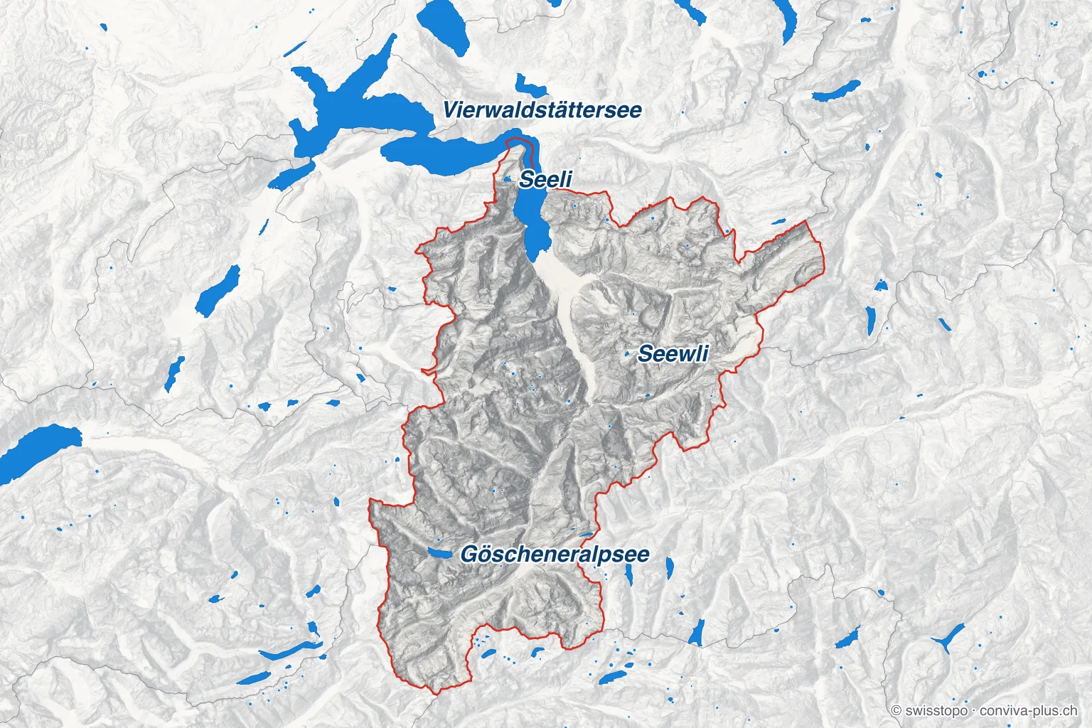
- Blue: every named lake of half a hectare or more, also beyond the cantonal border
- Dot: a lake too small to draw as an area; the bigger the dot, the bigger the lake
- Red line: the cantonal border; outside it the map is lightened, border lakes are drawn in full
- Labelled: the canton's largest lakes · Relief: swissALTIRegio, © swisstopo
Largest lake in Uri: Göscheneralpsee
The largest lake touching Uri is the Vierwaldstättersee (113.9 km²), but only 17% of its surface lies in the canton. The largest lake belonging entirely to the canton is the Göscheneralpsee: 1.29 km² at 1789 m.
| Lake | Area | Elevation | Share in canton |
|---|---|---|---|
| Lake Lucerne | 113.9 km² | 434 m | 17% |
| Göscheneralpsee | 1.29 km² | 1789 m | 100% |
| Oberalpsee | 19 ha | 2027 m | 100% |
| Seeli | 19 ha | 738 m | 100% |
| Seewli | 8.7 ha | 2027 m | 100% |
| Golzerensee | 6.0 ha | 1411 m | 100% |
| Hüfisee | 5.3 ha | 1635 m | 100% |
| Spilauer See | 4.6 ha | 1837 m | 100% |
| Arnisee | 4.5 ha | 1368 m | 100% |
| Gross See | 4.4 ha | 2338 m | 100% |
Reference works often give slightly different areas: we measure each water surface at the shoreline of the swissTLM3D landscape model (2026 edition).
🎣 Life on the water
On 5 January 1830, Uri boatmen hauled the market boat across the ice of the frozen lake. There is a single licence for the Urnersee, and fishing is open all year.
Highest lake in Uri: Tschingelsee
The highest lake in Uri is also one of the smallest: the Tschingelsee in Silenen lies at 2443 m and covers 1.1 ha; only 6 of the 29 lakes are smaller.
Elevation is the water level in the landscape model. 2 of the 29 lakes in the canton are held by a dam or embankment (structures in swissTLM3D): Göscheneralpsee and Arnisee. Their water level varies with how full they are.
Shared lakes: which lakes Uri shares
On Lake Lucerne, Uri only comes third (17%), behind Lucerne and Nidwalden. Uri shares 1 of its 29 lakes with other cantons; the table shows how much of each lies in the canton.
List of lakes in Uri
13 named bodies of water in Uri carry a word for "lake" in their name, yet none reaches half a hectare. The list shows all 43 officially named bodies of water in the canton, by area. The 29 lakes of half a hectare or more come first; smaller ponds are marked.
- 1.Vierwaldstättersee · 23 municipalities113.9 km²434 m
- 2.Göscheneralpsee · Göschenen1.29 km²1789 m
- 3.Oberalpsee · Andermatt19 ha2027 m
- 4.Seeli · Seelisberg19 ha738 m
- 5.Seewli · Silenen8.7 ha2027 m
- 6.Golzerensee · Silenen6.0 ha1411 m
- 7.Hüfisee · Silenen5.3 ha1635 m
- 8.Spilauer See · Sisikon4.6 ha1837 m
- 9.Arnisee · Gurtnellen4.5 ha1368 m
- 10.Gross See · Wassen4.4 ha2338 m
- 11.Obersee · Erstfeld3.9 ha1904 m
- 12.Seenalperseeli · Bürglen (UR)3.9 ha1719 m
- 13.Lutersee · Andermatt2.9 ha2357 m
- 14.Bergsee · Göschenen2.4 ha2341 m
- 15.Alpler See · Sisikon2.3 ha1506 m
- 16.Spillauisee · Silenen1.8 ha2231 m
- 17.Alpler See · Unterschächen1.7 ha2080 m
- 18.Bristensee · Silenen1.6 ha2098 m
- 19.Rossplattensee · Hospental1.4 ha2169 m
- 20.Fulensee · Erstfeld1.3 ha1705 m
- 21.Nidersee · Gurtnellen1.3 ha2091 m
- 22.Leidsee · Erstfeld1.2 ha2271 m
- 23.Tschingelsee · Silenen1.1 ha2443 m
- 24.Plattisee · Spiringen0.91 ha2099 m
- 25.Wijer · Seelisberg0.84 ha736 m
- 26.Wildenmattensee · Andermatt0.75 ha2284 m
- 27.Obersee · Gurtnellen0.66 ha2237 m
- 28.Chli See · Wassen0.60 ha2205 m
- 29.Hinterseeli · Gurtnellen0.55 ha2426 m
- From here: 14 waters with an official name but under half a hectare. Not a lake.
- 30.Älprigensee · Göschenen0.46 ha2510 m
- 31.Lang See · Wassen0.41 ha2309 m
- 32.Blauseeli · Realp0.38 ha2135 m
- 33.Sass Seeli · Gurtnellen0.37 ha2447 m
- 34.Luterseeli · Andermatt0.27 ha2281 m
- 35.Gruebenseeli · Göschenen0.26 ha1915 m
- 36.Gross Fläsch · Flüelen0.24 ha1803 m
- 37.Trübsee · Hospental0.23 ha1988 m
- 38.Lutersee · Hospental0.21 ha1975 m
- 39.Garschigsee · Realp0.17 ha2445 m
- 40.Chli Dürrseeli · Bürglen (UR)0.15 ha1871 m
- 41.Wandflueseeli · Göschenen990 m²1584 m
- 42.Hochstocksee · Realp720 m²2194 m
- 43.Gitschensee · Hospental430 m²2191 m
Lakes by size: a typical lake, three football pitches
A typical lake in Uri would fit on about three football pitches: half of the 29 lakes are smaller than 2.3 ha (a pitch is 105 × 68 m). 3 are smaller than a single pitch, and only 4 cover ten hectares or more.
Measured by area, the small lakes almost vanish: the 22 of the 29 lakes of half a hectare or more that stay under five hectares together cover about 2% of the lake surface in Uri.
The median lake in Uri sits 173 m higher than the median Swiss lake (1907 m).
Lakes by municipality: Silenen has the most
The municipality with the most lakes is not on the canton's largest lake (Lake Lucerne): Silenen, with 6 lakes, all above 1400 m.
- Silenen6Seewli · Golzerensee · Hüfisee · Spillauisee · Bristensee · Tschingelsee
- Gurtnellen4Arnisee · Nidersee · Obersee · Hinterseeli
- Andermatt3Oberalpsee · Lutersee · Wildenmattensee
- Erstfeld3Obersee · Fulensee · Leidsee
- Göschenen2Göscheneralpsee · Bergsee
- Seelisberg2Seeli · Wijer
- Sisikon2Spilauer See · Alpler See
- Wassen2Gross See · Chli See
Counted are lakes lying entirely within the canton and in no more than two municipalities; a large lake belongs to many. The Lake Finder can search by municipality.
How many lakes would you have guessed for Uri?
One click – anonymous, no sign-up required.
❓ Frequently asked questions about the lakes of Uri
People also ask
Related questions from our magazine
891 lakes of half a hectare or more, 29 of them in Uri, number 8 among the 26 cantons by count of lakes. Grisons has the most, with 236.
19 lakes of 0.5 ha or more; the largest entirely within the canton is Sempachersee, 14.4 km².
Residents, taxes, rents, wages and events: Uri in figures.
More lake pages

ConvivaPlus Editor · Data & Switzerland
Writes about Switzerland in figures – official data recalculated, counting method explained.
- Population
- 26 cantons
- Waterways
- Official data
All information without guarantee. Found an error? → support@conviva-plus.ch
Source: swisstopo (swissTLM3D, swissNAMES3D, swissBOUNDARIES3D, 2026 edition), analysis by ConvivaPlus. Switzerland as a whole: 891 lakes out of 17'873 water surfaces; parts with the same name no more than 50 m apart count as one lake. Area = water surface at the shoreline of the landscape model; reference works using a different shoreline or water level sometimes give other values.
Found an error or have feedback? Let us know or write to us directly.