Lakes in Neuchâtel 2026: all 7, with Lac des Brenets

Photo: JGS25, CC BY-SA 4.0 (cropped), Wikimedia Commons
On the Doubs, the border itself forms the lakes: the Lac des Brenets, Lac de Moron and Lac de Biaufond lie partly in Switzerland and partly in France. Entirely within Neuchâtel is the Lac des Taillères, at 1036 m.
Number of lakes in the canton of Neuchâtel: 7
7 lakes of half a hectare or more, and yet the national map shows 163 bodies of standing water in Neuchâtel. The gap is not imprecision; it is a way of counting.
- 1163 water surfaces appear in swisstopo's landscape model for the canton.
- 218 of them are at least half a hectare (5,000 m²).
- 38 carry an official name, however small.
- 47 are both, named and at least 0.5 ha. That is what we count as a lake.
A different figure almost always comes from a different cut-off: count only lakes over one square kilometre and the canton of Neuchâtel has 2. Even a plain name such as "Weiher" counts as official: what decides is the entry in the swissNAMES3D gazetteer. Our count states where the line is, so it can be checked.
Lake Finder: find any lake in Neuchâtel
Every officially named lake in Switzerland with area, elevation and canton. Filter by elevation and canton, search in all national languages.
- Municipalities: Estavayer · Cudrefin · Cheyres-Châbles · Concise · Delley-Portalban · Vully-les-Lacs · Chevroux · Cheseaux-Noréaz · Yvonand · Grandson · Corcelles-près-Concise · Gletterens · Onnens (VD) · Yverdon-les-Bains · Bonvillars · Neuchâtel · Milvignes · La Grande Béroche · Laténa · Cortaillod · Gampelen · Boudry · Montagny-près-YverdonOfficial names: Neuenburgersee · Lago di Neuchâtel · Lai da NeuchâtelArea by canton: Neuchâtel 39% · Vaud 35% · Fribourg 25% · Bern 0.9%
- Municipalities: Twann-Tüscherz · Erlach · Le Landeron · Biel/Bienne · Täuffelen · Sutz-Lattrigen · Lüscherz · Vinelz · La Neuveville · Mörigen · Ipsach · Ligerz · Gals · Nidau · HagneckOfficial names: Lac de Bienne · Lago di Bienne · Lai da BiennaArea by canton: Bern 99% · Neuchâtel 1%
- Area by canton: Neuchâtel 40% · rest abroad
- Area by canton: Neuchâtel 49% · rest abroad
- Municipalities: La Chaux-de-Fonds · Les Bois · La FerrièreArea by canton: Neuchâtel 14% · Jura 5% · Bern 3% · rest abroad
Source: swissTLM3D, swissNAMES3D, swissBOUNDARIES3D (© swisstopo, 2026 edition). Area = entire water surface, including the foreign part for border lakes. Elevation = water level in the landscape model. Analysis by ConvivaPlus.
Lake map: all 7 lakes in Neuchâtel
The map shows all 7 lakes in Neuchâtel where they lie, together with the lakes beyond the cantonal border.
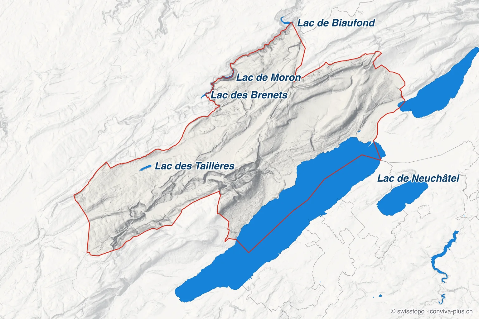
- Blue: every named lake of half a hectare or more, also beyond the cantonal border
- Dot: a lake too small to draw as an area; the bigger the dot, the bigger the lake
- Red line: the cantonal border; outside it the map is lightened, border lakes are drawn in full
- Labelled: the canton's largest lakes · Relief: swissALTIRegio, © swisstopo
Largest lake in Neuchâtel: Lac des Taillères
The largest lake touching Neuchâtel is the Lac de Neuchâtel (215.1 km²), but only 39% of its surface lies in the canton. The largest lake belonging entirely to the canton is the Lac des Taillères: 44 ha at 1036 m.
| Lake | Area | Elevation | Share in canton |
|---|---|---|---|
| Lake Neuchâtel | 215.1 km² | 429 m | 39% |
| Lake Biel | 39.5 km² | 429 m | 1% |
| Lac des Brenets | 67 ha | 751 m | 40% |
| Lac de Moron | 66 ha | 712 m | 49% |
| Lac de Biaufond | 56 ha | 609 m | 14% |
| Lac des Taillères | 44 ha | 1036 m | 100% |
| Le Loclat | 4.5 ha | 431 m | 100% |
Reference works often give slightly different areas: we measure each water surface at the shoreline of the swissTLM3D landscape model (2026 edition).
🎣 Life on the water
On 4 February 1830 Lake Neuchâtel froze over completely at −18 °C, and Neuchâtel went skating. It also froze over in 1695 and again in 1879. In February 1963 a boat stuck in the ice near the shore was freed with dynamite.
Highest lake in Neuchâtel: Lac des Taillères
Climb to the highest lake in Neuchâtel, the Lac des Taillères in La Brévine at 1036 m, and you are still below nearly seven in ten Swiss lakes: 67% lie higher. Even the lowest lake in Appenzell Innerrhoden lies above it: the Seealpsee at 1142 m.
Elevation is the water level in the landscape model. 2 of the 7 lakes in the canton are held by a dam or embankment (structures in swissTLM3D): Lac de Moron and Lac de Biaufond. Their water level varies with how full they are.
Shared lakes: which lakes Neuchâtel shares
Neuchâtel holds 39% of Lake Neuchâtel, barely more than Vaud (35%). Neuchâtel owns only a sliver of Bielersee: 1.2% of its area. Neuchâtel shares 5 of its 7 lakes, 3 with other cantons and 3 with other countries; the table shows how much of each lies in the canton.
List of lakes in Neuchâtel
The list shows all 8 officially named bodies of water in the canton, by area. The 7 lakes of half a hectare or more come first; smaller ponds are marked.
- 1.Lac de Neuchâtel · 23 municipalities215.1 km²429 m
- 2.Bielersee · 15 municipalities39.5 km²429 m
- 3.Lac des Brenets · Le Locle67 ha751 m
- 4.Lac de Moron · Les Planchettes, Le Locle66 ha712 m
- 5.Lac de Biaufond · 3 municipalities56 ha609 m
- 6.Lac des Taillères · La Brévine44 ha1036 m
- 7.Le Loclat · Laténa4.5 ha431 m
- From here: one water with an official name but under half a hectare. Not a lake.
- 8.L'Ecluse · Lignières790 m²802 m
Lakes by size: few, but large
Few, but large: half of the 7 lakes in Neuchâtel cover more than 66 ha, about 92 football pitches (105 × 68 m).
1 of the 7 lakes stay under five hectares.
The median lake in Neuchâtel sits 1298 m lower than the median Swiss lake (1907 m).
How many lakes would you have guessed for Neuchâtel?
One click – anonymous, no sign-up required.
❓ Frequently asked questions about the lakes of Neuchâtel
People also ask
Related questions from our magazine
891 lakes of half a hectare or more, 7 of them in Neuchâtel, number 17 among the 26 cantons by count of lakes. Grisons has the most, with 236.
86 lakes of 0.5 ha or more; the largest entirely within the canton is Thunersee, 47.8 km².
Residents, taxes, rents, wages and events: Neuchâtel in figures.
More lake pages
Sourced sentence by sentence · checked against the sources · researched with the help of artificial intelligence · How we work ›
 Published by Wojtek BernetFounder and publisher · Editorial ›
All information without guarantee. Found an error? → support@conviva-plus.ch
Source: swisstopo (swissTLM3D, swissNAMES3D, swissBOUNDARIES3D, 2026 edition), analysis by ConvivaPlus. Switzerland as a whole: 891 lakes out of 17'873 water surfaces; parts with the same name no more than 50 m apart count as one lake. Area = water surface at the shoreline of the landscape model; reference works using a different shoreline or water level sometimes give other values.
Found an error or have feedback? Let us know or write to us directly.